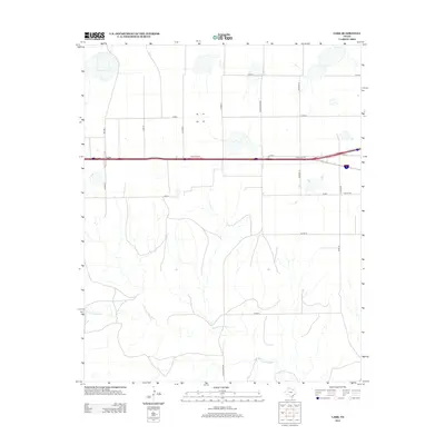
2012 Map of Lark
USGS Topo · Published 2012About this map
The settlement of Lark anchors this portion of the Texas Panhandle, positioned along a major east-west transportation corridor. The landscape is defined by the transition from high-plains agricultural grids to the drainage system of the Salt Fork Red River, which winds through the southern half of the quadrangle. Local landmarks such as the Groom Cem and specific rural markers like Charlie and Alpha Rd provide points of reference for genealogists and local historians tracing land use and family holdings in Carson County. The road network, including Ranch Road 284 and FM-2880, illustrates the modern infrastructure supporting this rural ranching and farming region while following established property lines and survey boundaries.
Find a feature on this map
21 named features on this map. Tap any name to fly to it.
Don’t see what you’re looking for? This feature index may not catch every label — zoom into the map to look around manually.
Map Details
Editions of this 2012 Lark Map
This is the sole edition of this map. No revisions or reprints were ever made.
Other maps of this area

1954 · Amarillo
USGS Topo · 1:250,000

1958 · Amarillo
USGS Topo · 1:250,000

1960 · Claude
USGS Topo · 1:62,500

1960 · Groom
USGS Topo · 1:62,500

1966 · Grandview School
USGS Topo · 1:24,000

1966 · Panhandle East
USGS Topo · 1:24,000

1966 · White Deer SW
USGS Topo · 1:24,000
1983 · Ashtola
USGS Topo · 1:24,000
1983 · Lark
USGS Topo · 1:24,000
1983 · Claude
USGS Topo · 1:24,000