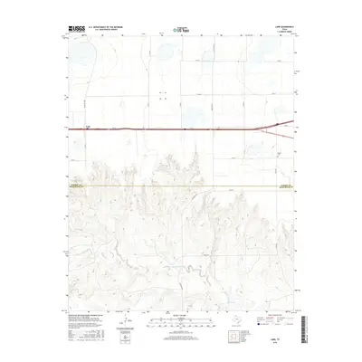
2016 Map of Lark
USGS Topo · Published 2016About this map
The settlement of Lark anchors this portion of the Texas Panhandle, sitting atop the high plains just north of a dramatic shift in geography. Below the Carson and Armstrong County line, the flat agricultural tableland gives way to the deeply eroded drainage systems of the Salt Fork Red River. This transition creates a stark contrast between the orderly grid of section roads like Co Rd 4 and Co Rd 3 in the north and the winding, topographically constrained routes like Charlie Rd and Alpha Rd that navigate the river's breaks.
Find a feature on this map
18 named features on this map. Tap any name to fly to it.
Don’t see what you’re looking for? This feature index may not catch every label — zoom into the map to look around manually.
Map Details
Editions of this 2016 Lark Map
This is the sole edition of this map. No revisions or reprints were ever made.
Other maps of this area

1954 · Amarillo
USGS Topo · 1:250,000

1958 · Amarillo
USGS Topo · 1:250,000

1960 · Claude
USGS Topo · 1:62,500

1960 · Groom
USGS Topo · 1:62,500

1966 · Grandview School
USGS Topo · 1:24,000

1966 · Panhandle East
USGS Topo · 1:24,000

1966 · White Deer SW
USGS Topo · 1:24,000
1983 · Ashtola
USGS Topo · 1:24,000
1983 · Lark
USGS Topo · 1:24,000
1983 · Claude
USGS Topo · 1:24,000