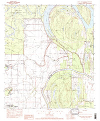
1982 Map of Larto Lake South
USGS Topo · Published 1982About this map
The low-lying wetlands of Catahoula Parish are defined by the intricate hydrology of the Red River and Larto Lake. This 1982 provisional survey documents a landscape dominated by water-management and wildlife preservation, notably within the Saline State Wildlife Management Area. The map shows a transition from the natural winding channels of Saline Bayou and Indigo Bayou to the engineered Powell Cutoff, reflecting the long-standing efforts to control flooding in these alluvial plains.
Find a feature on this map
62 named features on this map. Tap any name to fly to it.
Don’t see what you’re looking for? This feature index may not catch every label — zoom into the map to look around manually.
Map Details
Editions of this 1982 Larto Lake South Map
This is the sole edition of this map. No revisions or reprints were ever made.
Other maps of this area

1935 · Tooleys
USGS Topo · 1:62,500

1940 · Marksville
USGS Topo · 1:62,500

1941 · Voorhies
USGS Topo · 1:62,500

1941 · Buckeye
USGS Topo · 1:62,500

1941 · Tooleys
USGS Topo · 1:62,500

1953 · Alexandria
USGS Topo · 1:250,000

1953 · Natchez
USGS Topo · 1:250,000

1955 · Alexandria
USGS Topo · 1:250,000

1956 · Natchez
USGS Topo · 1:250,000

1959 · Natchez
USGS Topo · 1:250,000