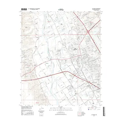
2017 Map of Las Cruces
USGS Topo · Published 2017About this map
The Rio Grande corridor in southern New Mexico defines the geography of this 2017 survey, where the river's path is paralleled by an intricate network of irrigation channels. These features, including the Leasburg Canal, Dona Ana Lateral, and Picacho Drain, reveal the engineering required to support agriculture and settlement in the arid Mesilla Valley. To the east, the urban center of Las Cruces expands toward the New Mexico State University - Main Campus, while historical pockets like Mesilla Park and Tortugas maintain their distinct identities. Cultural and community landmarks are frequent, notably the San Albino Ch and several local burial grounds such as Odd Fellow Cem and San Jose Cem. To the west, the landscape rises sharply into the Robledo Mountains and Apache Canyon, creating a stark contrast between the cultivated valley floor and the high desert terrain.
Find a feature on this map
55 named features on this map. Tap any name to fly to it.
Don’t see what you’re looking for? This feature index may not catch every label — zoom into the map to look around manually.
Map Details
Editions of this 2017 Las Cruces Map
This is the sole edition of this map. No revisions or reprints were ever made.
Other maps of this area

1891 · Las Cruces
USGS Topo · 1:125,000

1893 · Las Cruces
USGS Topo · 1:125,000

1941 · Las Cruces
USGS Topo · 1:62,500

1941 · Organ Peak
USGS Topo · 1:62,500

1943 · La Mesa
USGS Topo · 1:62,500

1943 · Organ Peak
USGS Topo · 1:62,500

1943 · Afton
USGS Topo · 1:62,500

1943 · Las Cruces
USGS Topo · 1:62,500
1955 · Tortugas Mountain
USGS Topo · 1:24,000
1955 · San Miguel
USGS Topo · 1:24,000