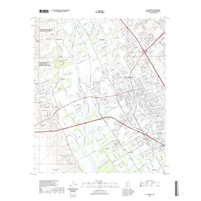
2020 Map of Las Cruces
USGS Topo · Published 2020About this map
The Rio Grande corridor anchors this modern survey of south-central New Mexico, showing the extensive network of irrigation canals that have sustained the Mesilla Valley for generations. A dense lattice of waterways including the Dona Ana Lateral, Elwood Lateral, and California Lateral weave through the landscape, supporting the communities of Mesilla, Fairacres, and San Ysidro. This intricate plumbing system reflects a long history of water management in an arid climate, defining the boundaries of local agriculture and settlement patterns.
Find a feature on this map
402 named features on this map. Tap any name to fly to it.
Don’t see what you’re looking for? This feature index may not catch every label — zoom into the map to look around manually.
Map Details
Editions of this 2020 Las Cruces Map
This is the sole edition of this map. No revisions or reprints were ever made.
Other maps of this area

1891 · Las Cruces
USGS Topo · 1:125,000

1893 · Las Cruces
USGS Topo · 1:125,000

1941 · Las Cruces
USGS Topo · 1:62,500

1941 · Organ Peak
USGS Topo · 1:62,500

1943 · La Mesa
USGS Topo · 1:62,500

1943 · Organ Peak
USGS Topo · 1:62,500

1943 · Afton
USGS Topo · 1:62,500

1943 · Las Cruces
USGS Topo · 1:62,500
1955 · Tortugas Mountain
USGS Topo · 1:24,000
1955 · San Miguel
USGS Topo · 1:24,000