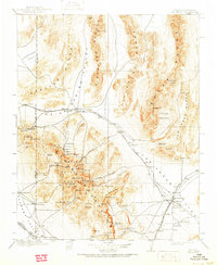
1908 Map of Las Vegas
USGS Topo · Published 1951About this map
Las Vegas is depicted here in its early years, appearing as a modest settlement near the Las Vegas Ranch and McWilliams townsite. The desert landscape is defined by the logistics of water and transport, with the San Pedro Los Angeles & Salt Lake RR and the Las Vegas and Tonopah RR converging in the valley. This 1906–1907 survey captures the high-desert economy of the era, where isolated outposts like Smith's Ranch and Pahrump Ranch served as vital hubs in an arid expanse.
Find a feature on this map
94 named features on this map. Tap any name to fly to it.
Don’t see what you’re looking for? This feature index may not catch every label — zoom into the map to look around manually.
Map Details
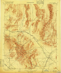
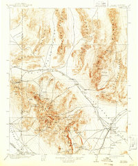
Editions of this 1908 Las Vegas Map
4 editions found
Other maps of this area

1885 · Pioche
USGS Topo · 1:250,000

1886 · Camp Mohave
USGS Topo · 1:250,000

1886 · Saint Thomas
USGS Topo · 1:250,000

1886 · Pioche
USGS Topo · 1:250,000

1892 · Camp Mohave
USGS Topo · 1:250,000

1893 · Saint Thomas
USGS Topo · 1:250,000

1907 · Las Vegas
USGS Topo · 1:250,000

1908 · Kawich
USGS Topo · 1:250,000

1908 · Furnace Creek
USGS Topo · 1:250,000

1908 · Las Vegas
USGS Topo · 1:250,000