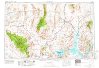
1954 Map of Las Vegas
USGS Topo · Published 1966About this map
The Las Vegas Valley is depicted here in a transformative mid-century era, showing the established core of Las Vegas alongside the rising industrial and suburban centers of North Las Vegas and Henderson. This 1:250,000 scale survey by the U.S. Geological Survey captures the region's complex identity, balancing civilian growth with massive military and restricted zones like the Las Vegas Bombing and Gunnery Range and Nellis Air Force Base. To the east, the Lake Mead National Recreation Area and the Virgin River provide a stark contrast to the surrounding desert terrain.
Find a feature on this map
77 named features on this map. Tap any name to fly to it.
Don’t see what you’re looking for? This feature index may not catch every label — zoom into the map to look around manually.
Map Details
Editions of this 1954 Las Vegas Map
5 editions found

Other maps of this area

1885 · St. George
USGS Topo · 1:250,000

1885 · Pioche
USGS Topo · 1:250,000

1886 · Diamond Creek
USGS Topo · 1:250,000

1886 · Camp Mohave
USGS Topo · 1:250,000

1886 · Saint Thomas
USGS Topo · 1:250,000

1886 · Mt. Trumbull
USGS Topo · 1:250,000

1886 · Pioche
USGS Topo · 1:250,000

1891 · St. George
USGS Topo · 1:250,000

1892 · Diamond Creek
USGS Topo · 1:250,000

1892 · Mt. Trumbull
USGS Topo · 1:250,000