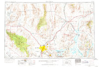
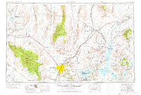
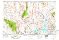
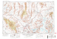
1954 Map of Las Vegas
USGS Topo · Published 1971About this map
The Spring Mountains and the Sheep Range define the dramatic topographical basin where Las Vegas began its mid-century expansion. This 1954 data, revised in the late 1960s, documents the city before its massive late-twentieth-century sprawl, showing distinct early residential clusters like North Las Vegas, Henderson, and Victory Village. The presence of the Stardust International Raceway and McCarran International Airport signals the region's burgeoning transition into a global destination. Beyond the neon, the map traces the critical infrastructure of the era, from the Hoover Dam and the Union Pacific railroad lines to the extensive Nellis Air Force Range and the Test Site (AEC) to the northwest. This survey provides a rare look at the valley's original spring-fed landscape, noting sites like Indian Springs and Cactus Springs before intensive modern development altered the groundwater and surface footprint of the Mojave.
Find a feature on this map
194 named features on this map. Tap any name to fly to it.
Don’t see what you’re looking for? This feature index may not catch every label — zoom into the map to look around manually.
Map Details
Editions of this 1954 Las Vegas Map
5 editions found

Other maps of this area

1885 · St. George
USGS Topo · 1:250,000

1885 · Pioche
USGS Topo · 1:250,000

1886 · Diamond Creek
USGS Topo · 1:250,000

1886 · Camp Mohave
USGS Topo · 1:250,000

1886 · Saint Thomas
USGS Topo · 1:250,000

1886 · Mt. Trumbull
USGS Topo · 1:250,000

1886 · Pioche
USGS Topo · 1:250,000

1891 · St. George
USGS Topo · 1:250,000

1892 · Diamond Creek
USGS Topo · 1:250,000

1892 · Mt. Trumbull
USGS Topo · 1:250,000