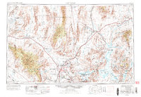
1954 Map of Las Vegas
USGS Topo · Published 1976About this map
The Las Vegas Valley is defined by rapid mid-century development and extensive military presence in this detailed regional study. While Las Vegas and North Las Vegas expand toward the Spring Mountains, the surrounding desert landscape is dominated by federal activity, including the sprawling Nellis Air Force Range and the Nevada Test Site (AEC). The map records a moment when recreational and industrial landmarks like the Stardust International Raceway and McCarran International Airport began to anchor the city’s southern edge near Henderson. To the east, the Virgin River feeds into the massive Lake Mead complex, where the Lake Mead National Recreation Area meets the dramatic topography of Mormon Mesa and the Muddy Mountains. This survey documents the critical water and transport networks, from the Union Pacific rail lines to the desert springs like Corn Creek Springs, that sustained the region's growth.
Find a feature on this map
135 named features on this map. Tap any name to fly to it.
Don’t see what you’re looking for? This feature index may not catch every label — zoom into the map to look around manually.
Map Details
Editions of this 1954 Las Vegas Map
5 editions found

Other maps of this area

1885 · St. George
USGS Topo · 1:250,000

1885 · Pioche
USGS Topo · 1:250,000

1886 · Diamond Creek
USGS Topo · 1:250,000

1886 · Camp Mohave
USGS Topo · 1:250,000

1886 · Saint Thomas
USGS Topo · 1:250,000

1886 · Mt. Trumbull
USGS Topo · 1:250,000

1886 · Pioche
USGS Topo · 1:250,000

1891 · St. George
USGS Topo · 1:250,000

1892 · Diamond Creek
USGS Topo · 1:250,000

1892 · Mt. Trumbull
USGS Topo · 1:250,000