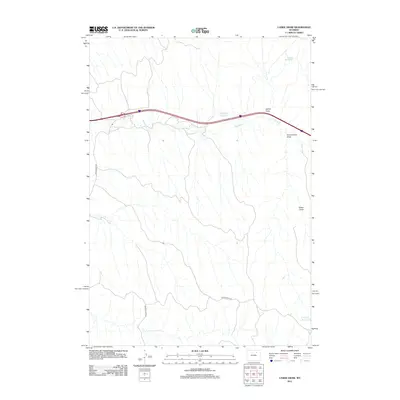
2012 Map of Laskie Draw
USGS Topo · Published 2012About this map
Laskie Draw carves through the arid landscape of Campbell County, Wyoming, as shown in this 2012 topographical study. The region is defined by its drainage systems and water management infrastructure, where seasonal watercourses like Dead Horse Cr are managed through several man-made catchments including Laskie Reservoir, the curiously named Bombsite Reservoir, and California Reservoir to the southeast. Transport across this terrain relies on a sparse network of unpaved access routes including Dead Horse Rd, Schoonover Rd, and Beaver Creek Rd. The map documents the intricate network of erosional features such as Government Draw and Karen Draw, which dictate the local topography and movement through this high plains environment.
Find a feature on this map
10 named features on this map. Tap any name to fly to it.
Don’t see what you’re looking for? This feature index may not catch every label — zoom into the map to look around manually.
Map Details
Editions of this 2012 Laskie Draw Map
This is the sole edition of this map. No revisions or reprints were ever made.
Other maps of this area

1954 · Gillette
USGS Topo · 1:250,000

1955 · Sheridan
USGS Topo · 1:250,000

1955 · Gillette
USGS Topo · 1:250,000

1958 · Gillette
USGS Topo · 1:250,000

1958 · Sheridan
USGS Topo · 1:250,000

1962 · Gillette
USGS Topo · 1:250,000

1962 · Sheridan
USGS Topo · 1:250,000
1971 · Bogie Draw
USGS Topo · 1:24,000
1971 · Morgan Draw
USGS Topo · 1:24,000
1972 · Carr Draw
USGS Topo · 1:24,000