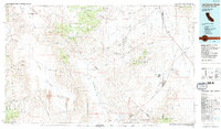
1985 Map of Last Chance Range
USGS Topo · Published 1985About this map
Death Valley National Monument anchors the southern portion of this mid-1980s survey, capturing a high-desert landscape defined by mining history and dramatic geology. The map documents a complex network of resource extraction across Slate Ridge and the Sylvania Mountains, featuring sites like the Sylvania Mine, Tokop Mine, and Oriental Mine. These workings are connected by a web of 4WD trails and an Old Railroad Grade that speaks to the era of industrial transport through the Lida Valley and Sarcobatus Flat.
Find a feature on this map
94 named features on this map. Tap any name to fly to it.
Don’t see what you’re looking for? This feature index may not catch every label — zoom into the map to look around manually.
Map Details
Editions of this 1985 Last Chance Range Map
2 editions found
Other maps of this area

1898 · Silver Peak
USGS Topo · 1:125,000

1900 · Silver Peak
USGS Topo · 1:125,000

1907 · Mt. Whitney
USGS Topo · 1:125,000

1908 · Kawich
USGS Topo · 1:250,000

1908 · Lida
USGS Topo · 1:250,000

1908 · Furnace Creek
USGS Topo · 1:250,000

1908 · Ballarat
USGS Topo · 1:250,000

1910 · Furnace Creek
USGS Topo · 1:250,000

1913 · Bishop
USGS Topo · 1:125,000

1913 · Lida
USGS Topo · 1:250,000