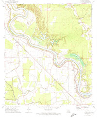
1972 Map of Latanier
USGS Topo · Published 1974About this map
The Red River dominates this landscape in Rapides Parish, creating a complex geography of oxbows and backwaters like Big Lake, Tarkill Lake, and Hog Lake. The meanders of the river define the transport and agricultural patterns of the early 1970s, with a prominent Levee system protecting low-lying fields. The Kansas City Southern railroad serves as the primary spine for settlements such as Latanier and Poland, connecting rural communities to the broader region. Small community churches and family burial grounds, including Riverview Church and Pearl Cemetery, are scattered across the alluvial plain, reflecting a deeply rooted local history. The map also captures specialized land uses of the era, from a Fish Farm to the Ruby Lookout Tower, illustrating the intersection of forestry, commerce, and rural life along the river valley.
Find a feature on this map
39 named features on this map. Tap any name to fly to it.
Don’t see what you’re looking for? This feature index may not catch every label — zoom into the map to look around manually.
Map Details
Editions of this 1972 Latanier Map
2 editions found
Other maps of this area

1935 · Lecompte
USGS Topo · 1:62,500

1940 · Marksville
USGS Topo · 1:62,500

1941 · Alexandria
USGS Topo · 1:62,500

1941 · Buckeye
USGS Topo · 1:62,500

1953 · Alexandria
USGS Topo · 1:250,000

1955 · Alexandria
USGS Topo · 1:250,000

1957 · Alexandria
USGS Topo · 1:62,500
1957 · Alexandria
USGS Topo · 1:24,000

1957 · Lecompte
USGS Topo · 1:62,500

1959 · Buckeye
USGS Topo · 1:62,500