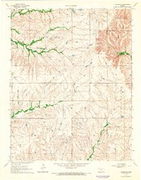
1964 Map of Latham SE
USGS Topo · Published 1965About this map
The Shinn Northeast Oil Field and scattered oil wells anchor the industrial character of this landscape in Butler and Elk counties during the early 1960s. The terrain is defined by a dense network of drainage systems, most notably Hickory Creek and its North Branch and South Branch forks, which dominate the northern half of the quadrangle. As the land transitions toward the southeast, the headwaters of the Elk River emerge, while Rock Creek and Grouse Creek carve through the central and southern portions. This survey captures a moment of active resource extraction in the Kansas uplands, showing the technical infrastructure of the oil industry laid over a complex watershed system.
Find a feature on this map
13 named features on this map. Tap any name to fly to it.
Don’t see what you’re looking for? This feature index may not catch every label — zoom into the map to look around manually.
Map Details
Editions of this 1964 Latham SE Map
This is the sole edition of this map. No revisions or reprints were ever made.
Other maps of this area

1885 · Eureka
USGS Topo · 1:125,000

1885 · Sedan
USGS Topo · 1:125,000

1888 · Eureka
USGS Topo · 1:125,000

1888 · Eldorado
USGS Topo · 1:125,000

1889 · Burden
USGS Topo · 1:125,000

1889 · Sedan
USGS Topo · 1:125,000

1894 · Eureka
USGS Topo · 1:125,000

1955 · Wichita
USGS Topo · 1:250,000

1958 · Wichita
USGS Topo · 1:250,000
1964 · Piedmont SW
USGS Topo · 1:24,000