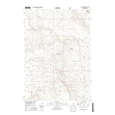
2013 Map of Latham Spring
USGS Topo · Published 2013About this map
Targhee National Forest defines the landscape of this high-elevation region along the Idaho-Montana border, where a complex network of mountain drainages feeds the regional river systems. The map detail highlights a rugged topography where Latham Spring emerges near the intersection of Black Canyon Loop Rd and Fish Creek Rd. This area is characterized by significant topographic shifts, from the level ground of Chick Creek Flat to the steep descent into Trail Canyon. The drainage pattern is particularly intricate, featuring the various branches of Split Cr, including the North, Middle, and South Forks, which carve through the forest alongside Moose Cr and Thirsty Cr. This 2013 survey provides an exacting record of the forest service roads and trails that navigate the high-country terrain of Fremont County and Gallatin County.
Find a feature on this map
25 named features on this map. Tap any name to fly to it.
Don’t see what you’re looking for? This feature index may not catch every label — zoom into the map to look around manually.
Map Details
Editions of this 2013 Latham Spring Map
This is the sole edition of this map. No revisions or reprints were ever made.
Other maps of this area

1955 · Ashton
USGS Topo · 1:250,000

1957 · Buffalo Lake
USGS Topo · 1:62,500

1958 · Ashton
USGS Topo · 1:250,000

1958 · West Yellowstone
USGS Topo · 1:62,500

1960 · Ashton
USGS Topo · 1:250,000

1964 · Hatchery Butte
USGS Topo · 1:24,000

1964 · Island Park
USGS Topo · 1:24,000

1964 · Big Springs
USGS Topo · 1:24,000

1964 · Henrys Lake
USGS Topo · 1:62,500
1986 · Jack Straw Basin
USGS Topo · 1:24,000