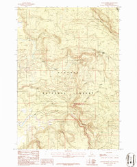
1986 Map of Latham Spring
USGS Topo · Published 1986About this map
Targhee National Forest defines this high-country terrain on the border of Fremont County, Idaho, and Gallatin County, Montana. The landscape is a network of watercourses, where the North Fork, Middle Fork, and South Fork join other drainage systems like Chick Creek and Moose Creek. A prominent Trail serves as the primary human mark in this wilderness, navigating the complex topography near Split Creek and Lucky Dog Cr. This 1980s-era survey emphasizes the hydrological intersections and elevation patterns before modern development. One notable feature, Latham Spring, stands as a critical water source in an area otherwise characterized by deep-cut features such as the Thirsty Black Creek Canyon. The map records a moment of transition between these two states, capturing the undeveloped character of the forest's interior.
Find a feature on this map
15 named features on this map. Tap any name to fly to it.
Don’t see what you’re looking for? This feature index may not catch every label — zoom into the map to look around manually.
Map Details
Editions of this 1986 Latham Spring Map
This is the sole edition of this map. No revisions or reprints were ever made.
Other maps of this area

1955 · Ashton
USGS Topo · 1:250,000

1957 · Buffalo Lake
USGS Topo · 1:62,500

1958 · Ashton
USGS Topo · 1:250,000

1958 · West Yellowstone
USGS Topo · 1:62,500

1960 · Ashton
USGS Topo · 1:250,000

1964 · Hatchery Butte
USGS Topo · 1:24,000

1964 · Island Park
USGS Topo · 1:24,000

1964 · Big Springs
USGS Topo · 1:24,000

1964 · Henrys Lake
USGS Topo · 1:62,500
1986 · Jack Straw Basin
USGS Topo · 1:24,000