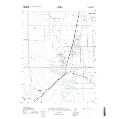
2018 Map of Lathrop
USGS Topo · Published 2018About this map
Lathrop and its surrounding agricultural and riverine landscape are defined by the complex waterways of the San Joaquin Delta. The San Joaquin River meanders through the center of the sheet, flanked by vital infrastructure like the Brandt Bridge and the Union Pacific Railroad. This 2018 survey illustrates the heavy intersection of transportation and irrigation, where the Old River and Paradise Cut separate larger landmasses such as Roberts Island from the developing outskirts of Manteca and Stockton. To the south, the settlement of Banta remains a distinct point of interest, anchored by the Banta Ch and surrounded by a dense network of local roads including S Roberts Rd and Kasson Rd. The presence of Oakwood Lake and the Walthall Slough highlights the managed nature of this low-lying terrain, where historical sloughs and modern transit corridors like I-5 and SR-120 coexist.
Find a feature on this map
125 named features on this map. Tap any name to fly to it.
Don’t see what you’re looking for? This feature index may not catch every label — zoom into the map to look around manually.
Map Details
Editions of this 2018 Lathrop Map
This is the sole edition of this map. No revisions or reprints were ever made.
Other maps of this area

1913 · Stockton
USGS Topo · 1:31,680

1913 · Holt
USGS Topo · 1:31,680

1914 · Burnham
USGS Topo · 1:31,680

1914 · Manteca
USGS Topo · 1:31,680

1914 · Union Island
USGS Topo · 1:31,680

1915 · Vernalis
USGS Topo · 1:31,680

1915 · Lathrop
USGS Topo · 1:31,680

1915 · Ripon
USGS Topo · 1:31,680

1916 · Tracy
USGS Topo · 1:31,680

1922 · Carbona
USGS Topo · 1:62,500