1950 Map of Latrobe
USGS Topo · Published 1950About this map
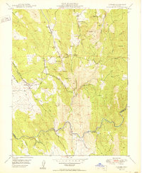
Latrobe serves as a central hub for the transport and ranching interests of southwestern El Dorado County at mid-century. The Southern Pacific railroad cuts across the foothills, connecting small outposts like Dugan and Brela while following the natural contours of Ben Bolt Ridge. The landscape is heavily marked by California's mining legacy, from the Vandalia Mine (Inactive) to the Copper Hill Mine near the southern boundary. These operations, alongside sites like the Sugarloaf Mine, suggest a region built on mineral extraction that slowly transitioned into more permanent ranching and agricultural use.
Find a feature on this map
36 named features on this map. Tap any name to fly to it.
Don’t see what you’re looking for? This feature index may not catch every label — zoom into the map to look around manually.
Map Details
Editions of this 1950 Latrobe Map
2 editions found

Other maps of this area

1889 · Jackson
USGS Topo · 1:125,000

1891 · Sacramento
USGS Topo · 1:125,000

1891 · Placerville
USGS Topo · 1:125,000

1892 · Jackson
USGS Topo · 1:125,000

1892 · Sacramento
USGS Topo · 1:125,000

1892 · Placerville
USGS Topo · 1:125,000

1893 · Placerville
USGS Topo · 1:125,000

1893 · Sacramento
USGS Topo · 1:125,000

1894 · Lodi
USGS Topo · 1:125,000

1897 · Jackson
USGS Topo · 1:125,000