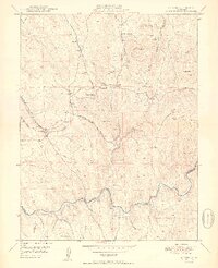
1950 Map of Latrobe
USGS Topo · Published 1950About this map
Latrobe stands as a focal point in this mid-century survey of the California foothills, situated along the Southern Pacific railroad line. The landscape reflects a legacy of extraction, where numerous industrial operations like the Vandalia Mine (Inactive) and Big Canyon Mine define the local economy alongside the Michigan Bar Ditch (Abandoned). This network of mines and waterworks, including the Sugarloaf Mine and Bugtown Mine (Inactive), suggests an era of significant transition as earlier gold-rush infrastructure became inactive.
Find a feature on this map
39 named features on this map. Tap any name to fly to it.
Don’t see what you’re looking for? This feature index may not catch every label — zoom into the map to look around manually.
Map Details
Editions of this 1950 Latrobe Map
2 editions found
Other maps of this area

1889 · Jackson
USGS Topo · 1:125,000

1891 · Sacramento
USGS Topo · 1:125,000

1891 · Placerville
USGS Topo · 1:125,000

1892 · Jackson
USGS Topo · 1:125,000

1892 · Sacramento
USGS Topo · 1:125,000

1892 · Placerville
USGS Topo · 1:125,000

1893 · Placerville
USGS Topo · 1:125,000

1893 · Sacramento
USGS Topo · 1:125,000

1894 · Lodi
USGS Topo · 1:125,000

1897 · Jackson
USGS Topo · 1:125,000