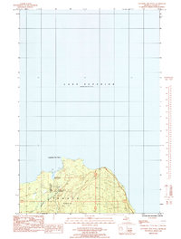
1985 Map of Laughing Fish Point
USGS Topo · Published 1985About this map
Laughing Fish Point juts into the cold waters of Lake Superior in this mid-1980s provisional survey of the Michigan shoreline. The landscape is defined by the winding course of the Laughing Whitefish River, which cuts through the Escanaba River State Forest before emptying into the lake. This map captures a largely recreational and conservation-focused era in Onota township, where the presence of the Laughing Whitefish Campground and the John H Hammer Public Access indicates the local importance of seasonal tourism and water access. The topography is documented in metric intervals, reflecting a specific period of cartographic transition for the Geological Survey as it moved toward modern manuscript drawings.
Find a feature on this map
10 named features on this map. Tap any name to fly to it.
Don’t see what you’re looking for? This feature index may not catch every label — zoom into the map to look around manually.
Map Details
Editions of this 1985 Laughing Fish Point Map
This is the sole edition of this map. No revisions or reprints were ever made.
Other maps of this area

1932 · Skandia NE
USGS Topo · 1:31,680

1958 · Au Train
USGS Topo · 1:62,500

1958 · Laughing Fish Point
USGS Topo · 1:62,500

1958 · Skandia
USGS Topo · 1:62,500

1958 · Marquette
USGS Topo · 1:250,000

1960 · Marquette
USGS Topo · 1:250,000

1961 · Marquette
USGS Topo · 1:250,000

1968 · Marquette
USGS Topo · 1:250,000
1983 · Gwinn
USGS Topo · 1:100,000

1983 · Munising
USGS Topo · 1:100,000