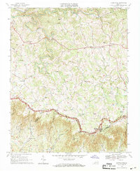
1968 Map of Laurel Fork
USGS Topo · Published 1971About this map
The Blue Ridge crest dictates the character of this 1968 landscape, where the Blue Ridge Parkway winds through the southern portion of the map along the border of Carroll and Patrick counties. This high-altitude terrain is defined by a dense network of mountain streams, most notably Big Reed Island Creek and its many tributaries like Potters Br and Pipestem Br. The settlement pattern reflects a dispersed rural community centered around small crossroads such as Laurel Fork and Gladesboro.
Find a feature on this map
44 named features on this map. Tap any name to fly to it.
Don’t see what you’re looking for? This feature index may not catch every label — zoom into the map to look around manually.
Map Details
Editions of this 1968 Laurel Fork Map
Other maps of this area

1889 · Hillsville
USGS Topo · 1:125,000

1892 · Hillsville
USGS Topo · 1:125,000

1896 · Hillsville
USGS Topo · 1:125,000

1928 · Stuart
USGS Topo · 1:48,000

1931 · Stuart
USGS Topo · 1:62,500

1953 · Winston-Salem
USGS Topo · 1:250,000

1955 · Winston-Salem
USGS Topo · 1:250,000

1956 · Macks Mountain
USGS Topo · 1:62,500

1957 · Mount Airy
USGS Topo · 1:62,500

1957 · Floyd
USGS Topo · 1:62,500