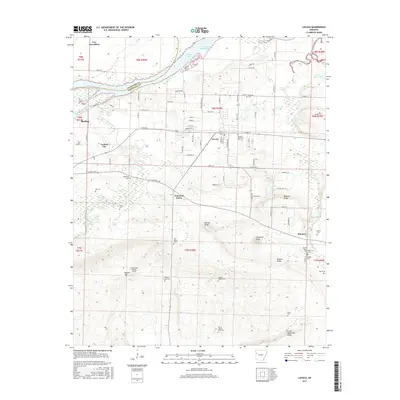
2017 Map of Lavaca
USGS Topo · Published 2017About this map
Ozark Lake and the Frustee Bend Cutoff define the northern border of this Arkansas landscape, where the Crawford Co Sebastian Co line crosses the water. The area is marked by a high concentration of family and community burial grounds, including the Measles Memorial Cem, Mayberry Cem, and William Teague Cem, providing significant touchpoints for genealogical research. Smaller settlements like Diamond Grove and Bloomer anchor the rural road network, while the southern terrain rises toward prominent features such as Biswell Hill and Little White Oak Ridge. A notable modern landmark is the Arrowhead Assault Strip located near the center of the sheet. The map illustrates a diverse geography where flat bottomlands near the Vache Grasse Creek meet the more defined elevations of Bloomer Ridge and Butlers Ridge, reflecting the agricultural and residential character of the region south of the river.
Find a feature on this map
84 named features on this map. Tap any name to fly to it.
Don’t see what you’re looking for? This feature index may not catch every label — zoom into the map to look around manually.
Map Details
Editions of this 2017 Lavaca Map
This is the sole edition of this map. No revisions or reprints were ever made.
Other maps of this area

1879 · Fort Smith
USGS Topo · 1:62,500

1887 · Van Buren
USGS Topo · 1:62,500

1887 · Greenwood
USGS Topo · 1:62,500

1890 · Fort Smith
USGS Topo · 1:125,000

1906 · Lavaca
USGS Topo · 1:62,500

1906 · Barber
USGS Topo · 1:62,500

1943 · Fort Smith
USGS Topo · 1:125,000

1946 · Fort Smith
USGS Topo · 1:250,000
1946 · Charleston
USGS Topo · 1:24,000

1947 · Lavaca
USGS Topo · 1:62,500