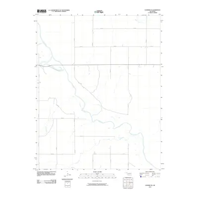
2010 Map of Laverne NE
USGS Topo · Published 2010About this map
The Beaver River meanders across this rural Oklahoma landscape, defining the local topography and drainage patterns. Flowing primarily from the northwest toward the southeast, the river is fed by several tributaries, including Spring Creek, Clear Creek, and Buffalo Creek. This area of Harper County is characterized by a precise rectilinear grid of section-line roads, such as N1770 Rd and E0190 Rd, which facilitate transport across the open plains. The map illustrates a region dedicated largely to agricultural and ranching pursuits, where the natural course of the waterways provides a stark contrast to the rigid human-imposed geometry of the township and range survey system. Small access ways like D1782 Rd branch off from the primary grid, leading toward the riparian corridors where the terrain shifts along the riverbanks.
Find a feature on this map
17 named features on this map. Tap any name to fly to it.
Don’t see what you’re looking for? This feature index may not catch every label — zoom into the map to look around manually.
Map Details
Editions of this 2010 Laverne NE Map
This is the sole edition of this map. No revisions or reprints were ever made.
Other maps of this area

1955 · Woodward
USGS Topo · 1:250,000

1958 · Woodward
USGS Topo · 1:250,000

1970 · Laverne SW
USGS Topo · 1:24,000

1970 · Buffalo
USGS Topo · 1:24,000

1971 · Rosston SE
USGS Topo · 1:24,000

1971 · May East
USGS Topo · 1:24,000

1971 · Rosston
USGS Topo · 1:24,000

1971 · Fort Supply NW
USGS Topo · 1:24,000
1971 · Laverne
USGS Topo · 1:24,000

1971 · Laverne NE
USGS Topo · 1:24,000