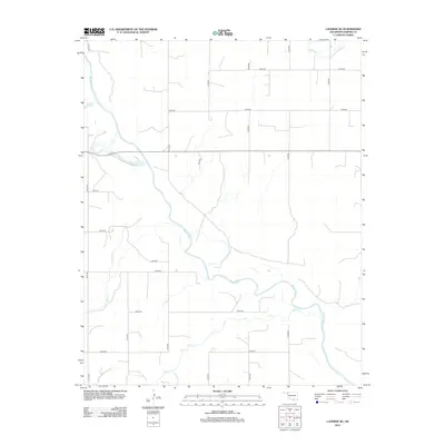
2012 Map of Laverne NE
USGS Topo · Published 2012About this map
The Beaver River meanders across this section of Harper County, carving a distinct hydrological path through the rural landscape. This Oklahoma panhandle survey reveals a territory defined by its watercourses and a strict section-line road grid. The confluence areas of Clear Cr and Spring Cr highlight the drainage patterns that have historically shaped local land use and ranching boundaries. Small tributaries like Buffalo Cr feed into the primary river system, which serves as the central geographic anchor for the region. The map documents an extensive network of rural routes, including N1770 Rd and E0250 Rd, illustrating how modern infrastructure follows the traditional cardinal-direction surveying of the western plains.
Find a feature on this map
20 named features on this map. Tap any name to fly to it.
Don’t see what you’re looking for? This feature index may not catch every label — zoom into the map to look around manually.
Map Details
Editions of this 2012 Laverne NE Map
This is the sole edition of this map. No revisions or reprints were ever made.
Other maps of this area

1955 · Woodward
USGS Topo · 1:250,000

1958 · Woodward
USGS Topo · 1:250,000

1970 · Laverne SW
USGS Topo · 1:24,000

1970 · Buffalo
USGS Topo · 1:24,000

1971 · Rosston SE
USGS Topo · 1:24,000

1971 · May East
USGS Topo · 1:24,000

1971 · Rosston
USGS Topo · 1:24,000

1971 · Fort Supply NW
USGS Topo · 1:24,000
1971 · Laverne
USGS Topo · 1:24,000

1971 · Laverne NE
USGS Topo · 1:24,000