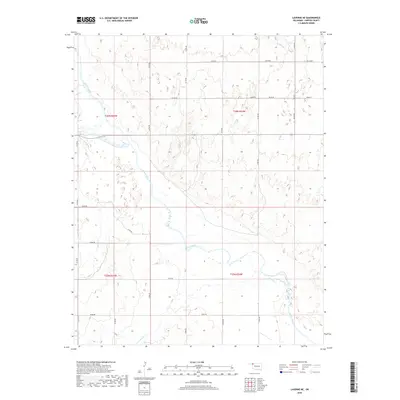
2018 Map of Laverne NE
USGS Topo · Published 2018About this map
The Beaver River carves a winding path through this corner of Harper County, defining a landscape shaped by hydrology and the Public Land Survey System. The river’s riparian corridor provides a stark contrast to the surrounding high plains, which are meticulously subdivided by a grid of rural roads including NS 180 Rd and N1790 Rd. These section lines organize the agricultural and ranching territory north of Laverne, revealing the systematic settlement patterns of the Oklahoma Panhandle region. Tributaries such as Buffalo Cr, Spring Cr, and Clear Cr feed into the main river channel, illustrating the drainage network that supports this prairie environment. The proximity to the Oklahoma-Kansas border is reflected in the township and range designations t26n r25w and t26n r24w, which anchor these rural homesteads and ranges within the larger western territory.
Find a feature on this map
28 named features on this map. Tap any name to fly to it.
Don’t see what you’re looking for? This feature index may not catch every label — zoom into the map to look around manually.
Map Details
Editions of this 2018 Laverne NE Map
This is the sole edition of this map. No revisions or reprints were ever made.
Other maps of this area

1955 · Woodward
USGS Topo · 1:250,000

1958 · Woodward
USGS Topo · 1:250,000

1970 · Laverne SW
USGS Topo · 1:24,000

1970 · Buffalo
USGS Topo · 1:24,000

1971 · Rosston SE
USGS Topo · 1:24,000

1971 · May East
USGS Topo · 1:24,000

1971 · Rosston
USGS Topo · 1:24,000

1971 · Fort Supply NW
USGS Topo · 1:24,000
1971 · Laverne
USGS Topo · 1:24,000

1971 · Laverne NE
USGS Topo · 1:24,000