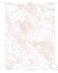
1955 Map of Lavic
USGS Topo · Published 1980About this map
The Atchison Topeka and Santa Fe railroad corridor cuts across the high Mojave landscape, marking the northern edge of a territory defined by volcanic activity and ephemeral basins. The dry beds of Lavic Lake and Galway Lake serve as distinct markers amidst the surrounding peaks, while Pisgah Crater and extensive lava fields dominate the northern quadrant. This 1955 survey captures a period when the region was heavily utilized for military and industrial purposes, with much of the land designated as a Naval Reservation and a training center.
Find a feature on this map
33 named features on this map. Tap any name to fly to it.
Don’t see what you’re looking for? This feature index may not catch every label — zoom into the map to look around manually.
Map Details
Editions of this 1955 Lavic Map
3 editions found

Other maps of this area

1901 · Southern California Sheet No. 1
USGS Topo · 1:250,000

1902 · San Gorgonio
USGS Topo · 1:125,000

1904 · Southern California Sheet No. 1
USGS Topo · 1:250,000

1953 · San Bernardino
USGS Topo · 1:250,000

1954 · Galway Lake
USGS Topo · 1:24,000

1954 · Hidalgo Mtn
USGS Topo · 1:24,000

1954 · Emerson Lake
USGS Topo · 1:24,000

1955 · Deadman Lake NW
USGS Topo · 1:24,000

1955 · Ludlow
USGS Topo · 1:24,000

1955 · Lavic SE
USGS Topo · 1:24,000