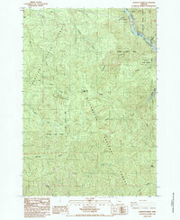
1985 Map of Lawhead Creek
USGS Topo · Published 1985About this map
Santiam State Forest and the Willamette National Forest dominate this mid-1980s terrain where the Marion and Linn county line follows the course of the Santiam River. The map highlights the engineered waterways of the region, specifically the Big Cliff Reservoir and the western edge of Detroit Lake, which shaped the local economy and recreation of the era. A dense network of drainages, including Lawhead Creek, Sevenmile Creek, and Thomas Creek, carve through the timberlands between high points like Monument Peak and the Palisades. This survey reflects the complex management of public lands and water resources in the Oregon Cascades, showing the distribution of forest boundaries and state-maintained areas at a time of peak timber and hydroelectric activity.
Find a feature on this map
22 named features on this map. Tap any name to fly to it.
Don’t see what you’re looking for? This feature index may not catch every label — zoom into the map to look around manually.
Map Details
Editions of this 1985 Lawhead Creek Map
This is the sole edition of this map. No revisions or reprints were ever made.
Other maps of this area

1929 · Mill City
USGS Topo · 1:125,000

1953 · Salem
USGS Topo · 1:250,000

1954 · Salem
USGS Topo · 1:250,000

1955 · Mill City
USGS Topo · 1:62,500

1956 · Quartzville
USGS Topo · 1:62,500

1956 · Battle Ax
USGS Topo · 1:62,500

1956 · Detroit
USGS Topo · 1:62,500

1960 · Salem
USGS Topo · 1:250,000

1962 · Salem
USGS Topo · 1:250,000

1963 · Salem
USGS Topo · 1:250,000