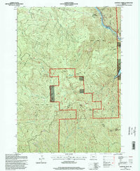
1994 Map of Lawhead Creek
USGS Topo · Published 1998About this map
Detroit Lake Reservoir dominates the eastern edge of this landscape, where the waters of the Santiam State Forest meet the Willamette National Forest. This 1994 survey, updated by the Forest Service, documents a heavily managed timber landscape at the end of the 20th century. The intricate network of 4wd roads and various Quarry and Pit locations indicates the active maintenance of forest infrastructure. High points like Monument Peak and the Palisades define the drainage basins for Lawhead Creek and Geneva Creek, which feed into the primary reservoir system. The map also delineates the administrative boundary between the Detroit Ranger District and the Sweet Home Ranger District, illustrating the division of federal land management across the Santiam River's tributary network.
Find a feature on this map
22 named features on this map. Tap any name to fly to it.
Don’t see what you’re looking for? This feature index may not catch every label — zoom into the map to look around manually.
Map Details
Editions of this 1994 Lawhead Creek Map
This is the sole edition of this map. No revisions or reprints were ever made.
Other maps of this area

1929 · Mill City
USGS Topo · 1:125,000

1953 · Salem
USGS Topo · 1:250,000

1954 · Salem
USGS Topo · 1:250,000

1955 · Mill City
USGS Topo · 1:62,500

1956 · Quartzville
USGS Topo · 1:62,500

1956 · Battle Ax
USGS Topo · 1:62,500

1956 · Detroit
USGS Topo · 1:62,500

1960 · Salem
USGS Topo · 1:250,000

1962 · Salem
USGS Topo · 1:250,000

1963 · Salem
USGS Topo · 1:250,000