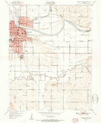
1950 Map of Lawrence East
USGS Topo · Published 1952About this map
The University of Kansas and the Haskell Institute anchor the western edge of this mid-century landscape, where the urban grid of Lawrence meets the wide floodplains of the Kansas River. The map reveals a dense network of local education and community life, tracing numerous rural schoolhouses such as Bismarck Sch, Walnut Grove Sch, and Fairview Sch. To the north, the Union Pacific tracks pass through Bismarck Grove, while the Atchison Topeka and Santa Fe railroad skirts the southern bluffs near Blue Mound. The terrain is defined by the winding course of the Wakarusa River and its tributaries like Coal Creek, protected in parts by a Levee system. This 1950s survey captures the city's eastern expansion and the critical intersection of major rail lines and river valleys that shaped Douglas County's development.
Find a feature on this map
51 named features on this map. Tap any name to fly to it.
Don’t see what you’re looking for? This feature index may not catch every label — zoom into the map to look around manually.
Map Details
Editions of this 1950 Lawrence East Map
4 editions found
Other maps of this area

1885 · Lawrence
USGS Topo · 1:125,000

1886 · Oskaloosa
USGS Topo · 1:125,000

1888 · Oskaloosa
USGS Topo · 1:125,000

1889 · Lawrence
USGS Topo · 1:125,000

1894 · Oskaloosa
USGS Topo · 1:125,000

1947 · Lawrence
USGS Topo · 1:250,000

1949 · Williamstown
USGS Topo · 1:24,000

1950 · Kansas City
USGS Topo · 1:250,000

1950 · Williamstown
USGS Topo · 1:24,000

1950 · Lawrence
USGS Topo · 1:250,000