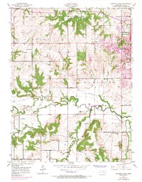
1950 Map of Lawrence West
USGS Topo · Published 1968About this map
The Kansas River and Wakarusa River define the alluvial landscape of this Douglas County quadrangle, where the westward expansion of Lawrence meets the rural townships of Kanwaka and Wakarusa. This 1950 survey, photorevised in 1967, documents the mid-century evolution of the University of Kansas, including the development of its West Campus. The transition from agrarian roots to suburban growth is visible in the presence of several country schools like Brackett Sch and School No 6, contrasted with newer car-culture landmarks such as a Drive-in Theater, a Drag Strip, and the Sunset Hills Shopping Sch.
Find a feature on this map
33 named features on this map. Tap any name to fly to it.
Don’t see what you’re looking for? This feature index may not catch every label — zoom into the map to look around manually.
Map Details
Editions of this 1950 Lawrence West Map
4 editions found
Other maps of this area

1885 · Lawrence
USGS Topo · 1:125,000

1886 · Oskaloosa
USGS Topo · 1:125,000

1888 · Oskaloosa
USGS Topo · 1:125,000

1889 · Lawrence
USGS Topo · 1:125,000

1894 · Oskaloosa
USGS Topo · 1:125,000

1947 · Lawrence
USGS Topo · 1:250,000

1949 · Williamstown
USGS Topo · 1:24,000

1949 · Perry
USGS Topo · 1:24,000

1950 · Perry
USGS Topo · 1:24,000

1950 · Kansas City
USGS Topo · 1:250,000