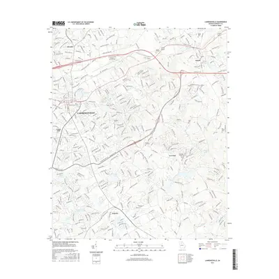
2017 Map of Lawrenceville
USGS Topo · Published 2017About this map
Lawrenceville serves as the focal point of this Gwinnett County landscape, revealing the modern infrastructure and historic markers of a rapidly developing suburban corridor. The presence of numerous family and church burial grounds, such as the Dacula Baptist Cem, McHaffey Cem, and Pharr Cem, provides a detailed record of local genealogy amidst the sprawling residential street networks. The northern section is dominated by the Gwinnett County Airport - Briscoe Field and industrial zones, while the southern reaches follow the hydrology of the Yellow River and Bay Creek. Notable landmarks like Martins Chapel Hill and Lawrenceville City Lake highlight the intersection of natural terrain and civic planning. This survey documents the area's transition into a major metropolitan hub while preserving the location of smaller historical sites like New Hope and Allendale.
Find a feature on this map
305 named features on this map. Tap any name to fly to it.
Don’t see what you’re looking for? This feature index may not catch every label — zoom into the map to look around manually.
Map Details
Editions of this 2017 Lawrenceville Map
This is the sole edition of this map. No revisions or reprints were ever made.
Other maps of this area

1888 · Atlanta
USGS Topo · 1:125,000

1890 · Suwanee
USGS Topo · 1:125,000

1890 · Atlanta
USGS Topo · 1:125,000

1891 · Gainesville
USGS Topo · 1:125,000

1892 · Atlanta
USGS Topo · 1:125,000

1894 · Suwanee
USGS Topo · 1:125,000

1895 · Atlanta
USGS Topo · 1:125,000

1896 · Monroe
USGS Topo · 1:125,000

1953 · Atlanta
USGS Topo · 1:250,000

1953 · Athens
USGS Topo · 1:250,000