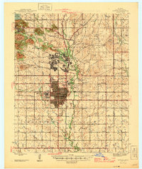
1946 Map of Lawton
USGS Topo · Published 1946About this map
The Fort Sill Military Reservation dominates the northern landscape of this mid-century Oklahoma study, showcasing a dense network of military infrastructure including a Rifle Range and a dedicated Sewage Disposal plant. To the south, the city of Lawton is depicted in its post-war growth phase, anchored by the Cameron State Agricultural College and served by two major rail lines, the St Louis San Francisco and the Chicago Rock Island and Pacific.
Find a feature on this map
65 named features on this map. Tap any name to fly to it.
Don’t see what you’re looking for? This feature index may not catch every label — zoom into the map to look around manually.
Map Details
Editions of this 1946 Lawton Map
2 editions found
Other maps of this area

1937 · Cache
USGS Topo · 1:48,000

1942 · Cache
USGS Topo · 1:62,500

1946 · Lawton
USGS Topo · 1:62,500

1949 · Mount Scott
USGS Topo · 1:24,000

1949 · Arbuckle Hill
USGS Topo · 1:24,000

1949 · Cement
USGS Topo · 1:62,500

1949 · Elgin
USGS Topo · 1:24,000

1949 · Fort Sill
USGS Topo · 1:24,000

1949 · Nellie
USGS Topo · 1:62,500

1950 · Saddle Mountain
USGS Topo · 1:62,500
Featured Places
- Lawton, OK
- Medicine Park, OK
- white Wolf Manor, Lawton
- Artillery Village Greenspace, Lawton
- 10 Mile Crossing, OK