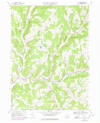
1967 Map of Lawton
USGS Topo · Published 1978About this map
Wyalusing Creek carves a central path through this landscape, serving as a geographic anchor for several small rural settlements during the late 1960s. The village of Lawton sits at a critical junction of creek branches and roads, while Rushville and Rush mark the western and central reaches of the valley. This 1967 survey (updated in 1978) highlights a deeply rooted agricultural and local community structure, evident in the high density of family and institutional burial grounds like Steadwell Cem, Devine Ridge Cem, and the County Home Cem near the County Home. Numerous quarries and gravel pits scattered across the hillsides of Middletown and Rush townships point to the local extraction industries that shaped the economy alongside the creek-bottom farms. Higher elevations like Devine Ridge and Fowler Hill overlook a network of smaller tributaries, including Gaylord Creek and Deuel Creek, which feed into the primary drainage system.
Find a feature on this map
40 named features on this map. Tap any name to fly to it.
Don’t see what you’re looking for? This feature index may not catch every label — zoom into the map to look around manually.
Map Details
Editions of this 1967 Lawton Map
Other maps of this area

1943 · Montrose
USGS Topo · 1:62,500

1943 · Le Raysville
USGS Topo · 1:62,500

1945 · Montrose
USGS Topo · 1:62,500

1945 · Le Raysville
USGS Topo · 1:62,500

1945 · Meshoppen
USGS Topo · 1:62,500

1945 · Auburn Center
USGS Topo · 1:24,000

1945 · Laceyville
USGS Topo · 1:24,000

1946 · Tunkhannock
USGS Topo · 1:62,500

1946 · Springville
USGS Topo · 1:24,000
1947 · Auburn Center
USGS Topo · 1:31,680