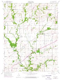
1956 Map of Le Loup
USGS Topo · Published 1976About this map
The Atchison Topeka And Santa Fe railway anchors this landscape, cutting southwest through the rural terrain of Franklin and Palmyra. Small rural communities like Le Loup and Norwood serve as focal points for a farming district defined by its network of schools and churches, including the Tauy Ch and Center Chapel. This area reflects the mid-century transition of the Kansas prairie, where the Old Indian Boundary remains a visible line of history across the township plats.
Find a feature on this map
29 named features on this map. Tap any name to fly to it.
Don’t see what you’re looking for? This feature index may not catch every label — zoom into the map to look around manually.
Map Details
Editions of this 1956 Le Loup Map
2 editions found
Other maps of this area

1885 · Lawrence
USGS Topo · 1:125,000

1889 · Lawrence
USGS Topo · 1:125,000

1947 · Lawrence
USGS Topo · 1:250,000

1950 · Lawrence
USGS Topo · 1:250,000

1956 · Wellsville
USGS Topo · 1:24,000

1956 · Ottawa North
USGS Topo · 1:24,000

1956 · Le Loup
USGS Topo · 1:24,000

1956 · Ottawa South
USGS Topo · 1:24,000
1956 · Edgerton
USGS Topo · 1:24,000

1956 · Lawrence
USGS Topo · 1:250,000