
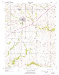
1956 Map of Wellsville
USGS Topo · Published 1957About this map
Wellsville serves as the primary hub of this eastern Kansas landscape, situated at the junction of significant transportation and drainage networks during the mid-1950s. The town's grid is bisected by the Santa Fe and Topeka Atchison railroad, which historically dictated the commercial orientation of the community. Rural life is anchored by a series of local institutions, including the Rock Creek Sch and West Windy Sch, alongside several community burial grounds like the Wellsville Cem and Walnut Creek Cem.
Find a feature on this map
30 named features on this map. Tap any name to fly to it.
Don’t see what you’re looking for? This feature index may not catch every label — zoom into the map to look around manually.
Map Details
Editions of this 1956 Wellsville Map
2 editions found
Other maps of this area

1885 · Lawrence
USGS Topo · 1:125,000

1887 · Olathe
USGS Topo · 1:125,000

1889 · Lawrence
USGS Topo · 1:125,000

1893 · Olathe
USGS Topo · 1:125,000

1947 · Lawrence
USGS Topo · 1:250,000

1950 · Lawrence
USGS Topo · 1:250,000

1956 · Le Loup
USGS Topo · 1:24,000
1956 · Edgerton
USGS Topo · 1:24,000

1956 · Lawrence
USGS Topo · 1:250,000
1957 · Paola West
USGS Topo · 1:24,000