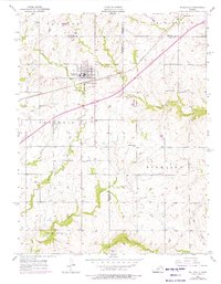
1956 Map of Wellsville
USGS Topo · Published 1976About this map
Wellsville stands as the primary hub of this eastern Kansas landscape, situated at the convergence of several county lines including Franklin, Douglas, Miami, and Johnson. The town is physically defined by its relationship to the Atchison Topeka and Santa Fe railroad, which cuts a straight path through the township. The surrounding rural areas are organized into distinct districts like Palmyra, McCamish, and Richland, where family life was anchored by local institutions such as West Windy Sch and Rock Creek Sch. Numerous cemeteries, including Walnut Creek Cem and Rock Creek Cem, provide vital touchpoints for genealogical research. The terrain is deeply etched by a network of drainage systems including Walnut Creek, Turkey Creek, and Field Creek, which dictated the early placement of farmsteads and rural roads before the mid-20th-century expansion of oil exploration, evidenced by scattered oil wells.
Find a feature on this map
31 named features on this map. Tap any name to fly to it.
Don’t see what you’re looking for? This feature index may not catch every label — zoom into the map to look around manually.
Map Details
Editions of this 1956 Wellsville Map
2 editions found
Other maps of this area

1885 · Lawrence
USGS Topo · 1:125,000

1887 · Olathe
USGS Topo · 1:125,000

1889 · Lawrence
USGS Topo · 1:125,000

1893 · Olathe
USGS Topo · 1:125,000

1947 · Lawrence
USGS Topo · 1:250,000

1950 · Lawrence
USGS Topo · 1:250,000

1956 · Wellsville
USGS Topo · 1:24,000

1956 · Le Loup
USGS Topo · 1:24,000
1956 · Edgerton
USGS Topo · 1:24,000

1956 · Lawrence
USGS Topo · 1:250,000