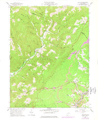
1959 Map of Lead Mine
USGS Topo · Published 1978About this map
Backbone Mountain divides this high-elevation landscape, where the headwaters of the Horseshoe Run and various mountain forks carved the terrain of the Monongahela National Forest. By the late 1950s, the southeastern corner of the map reveals a concentrated industrial and residential pocket along the Western Maryland railroad line. Here, the communities of Thomas, Coketon, and Douglas sit amidst numerous strip mines, reflecting the coal-driven economy of the era.
Find a feature on this map
69 named features on this map. Tap any name to fly to it.
Don’t see what you’re looking for? This feature index may not catch every label — zoom into the map to look around manually.
Map Details
Editions of this 1959 Lead Mine Map
3 editions found
Other maps of this area

1886 · St. George
USGS Topo · 1:125,000

1891 · St. George
USGS Topo · 1:125,000

1895 · Piedmont
USGS Topo · 1:125,000

1899 · Oakland
USGS Topo · 1:62,500

1900 · Oakland
USGS Topo · 1:62,500

1907 · Kingwood
USGS Topo · 1:62,500

1908 · Parsons
USGS Topo · 1:62,500

1916 · Davis
USGS Topo · 1:48,000

1918 · Davis
USGS Topo · 1:62,500

1919 · Davis
USGS Topo · 1:62,500