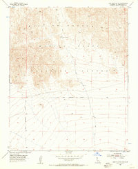
1955 Map of Lead Mountain SW
USGS Topo · Published 1957About this map
The Bullion Mountains dominate this mid-century desert landscape, illustrating a period of intense military activity within San Bernardino County. Much of the northern terrain is occupied by the Marine Corps Training Center, while the southern reaches are defined by a clear Naval Reservation Boundary. Topographic details reveal the high-elevation passage at Cleghorn Pass, a natural corridor through the steep ridges. Outside of the primary reservation limits, the land is marked by an occasional Jeep Trail, indicating the sparse infrastructure and remote nature of the region during the 1950s. This survey, compiled from 1952 aerial photography, captures the exact limits of these military zones at a time of significant post-war expansion in the California desert.
Find a feature on this map
6 named features on this map. Tap any name to fly to it.
Don’t see what you’re looking for? This feature index may not catch every label — zoom into the map to look around manually.
Map Details
Editions of this 1955 Lead Mountain SW Map
3 editions found
Other maps of this area

1942 · Amboy
USGS Topo · 1:250,000

1943 · Amboy
USGS Topo · 1:250,000

1953 · San Bernardino
USGS Topo · 1:250,000

1954 · Needles
USGS Topo · 1:250,000

1954 · Valley Mtn
USGS Topo · 1:24,000

1955 · Lead Mountain
USGS Topo · 1:24,000

1955 · Deadman Lake SE
USGS Topo · 1:24,000

1955 · Lead Mtn. NE
USGS Topo · 1:24,000

1955 · Deadman Lake NE
USGS Topo · 1:24,000

1955 · Lead Mountain SW
USGS Topo · 1:24,000