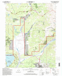
1994 Map of Leadville North
USGS Topo · Published 1998About this map
The high-altitude mining and recreation landscape of the Continental Divide is documented here as it appeared in the late 1980s and early 1990s. The city of Leadville anchors the southeast corner, surrounded by a dense network of historic mining claims and landmarks including Fryer Hill, the Matchless Mine, and the Jennie June Mine. The industrial heritage is visible in the rail lines of the Burlington Northern and the Leadville Junction area, while the growth of local infrastructure is noted at the West Park Sch and the Evergreen Cem.
Find a feature on this map
85 named features on this map. Tap any name to fly to it.
Don’t see what you’re looking for? This feature index may not catch every label — zoom into the map to look around manually.
Map Details
Editions of this 1994 Leadville North Map
This is the sole edition of this map. No revisions or reprints were ever made.
Other maps of this area

1889 · Leadville
USGS Topo · 1:125,000

1891 · Leadville
USGS Topo · 1:125,000

1934 · Climax
USGS Topo · 1:48,000

1935 · Mount Elbert
USGS Topo · 1:62,500

1938 · Mt. Lincoln
USGS Topo · 1:48,000

1938 · Mount Elbert
USGS Topo · 1:62,500

1939 · Mount Elbert
USGS Topo · 1:62,500

1942 · Leadville
USGS Topo · 1:125,000

1945 · Mount Lincoln
USGS Topo · 1:62,500

1949 · Holy Cross
USGS Topo · 1:62,500