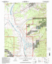
1994 Map of Leadville South
USGS Topo · Published 1998About this map
California Gulch serves as a central artery for the historic mining district south of Leadville, revealing a landscape heavily shaped by nineteenth-century industry and subsequent remediation. The map details numerous historic sites such as Adelaide and Oro, alongside active remnants of the silver boom like the Yak Tunnel and Resurrection Mill. While the eastern slopes are dominated by mine-related terrain including Carbonate Hill and Yankee Hill, the western portion of the sheet transitions into the managed landscapes of the San Isabel National Forest and the Turquoise Lake Recreation Area. The Arkansas River valley floor contains essential infrastructure including the County Airport and the Leadville Junction rail connection. The presence of both the St Joseph and Evergreen cemeteries provides a valuable resource for genealogists researching the families that built this high-altitude community.
Find a feature on this map
75 named features on this map. Tap any name to fly to it.
Don’t see what you’re looking for? This feature index may not catch every label — zoom into the map to look around manually.
Map Details
Editions of this 1994 Leadville South Map
This is the sole edition of this map. No revisions or reprints were ever made.
Other maps of this area

1889 · Leadville
USGS Topo · 1:125,000

1891 · Leadville
USGS Topo · 1:125,000

1934 · Climax
USGS Topo · 1:48,000

1935 · Mount Elbert
USGS Topo · 1:62,500

1938 · Mt. Lincoln
USGS Topo · 1:48,000

1938 · Mount Elbert
USGS Topo · 1:62,500

1939 · Mount Elbert
USGS Topo · 1:62,500

1942 · Leadville
USGS Topo · 1:125,000

1945 · Mount Lincoln
USGS Topo · 1:62,500

1949 · Holy Cross
USGS Topo · 1:62,500