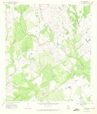
1968 Map of Leal
USGS Topo · Published 1971About this map
The Atascosa River winds through the southwestern corner of this landscape, carving a fertile valley in the South Texas brush country just before the turn of the 1970s. The small settlement of Leal sits central to the river's path, supported by the Missouri Pacific railroad line that parallels the water. This area is defined by a dense network of intermittent drainages, including Lucas Creek, Prieto Creek, and Borrego Creek, which delineate the rolling terrain.
Find a feature on this map
17 named features on this map. Tap any name to fly to it.
Don’t see what you’re looking for? This feature index may not catch every label — zoom into the map to look around manually.
Map Details
Editions of this 1968 Leal Map
This is the sole edition of this map. No revisions or reprints were ever made.
Other maps of this area

1931 · Falls City
USGS Topo · 1:62,500

1936 · Floresville
USGS Topo · 1:62,500

1953 · Crystal City
USGS Topo · 1:250,000

1954 · San Antonio
USGS Topo · 1:250,000

1955 · Crystal City
USGS Topo · 1:250,000

1956 · Pleasanton
USGS Topo · 1:62,500

1957 · San Antonio
USGS Topo · 1:250,000

1961 · Crystal City
USGS Topo · 1:250,000
1961 · Dewees
USGS Topo · 1:24,000
1961 · Three Oaks
USGS Topo · 1:24,000