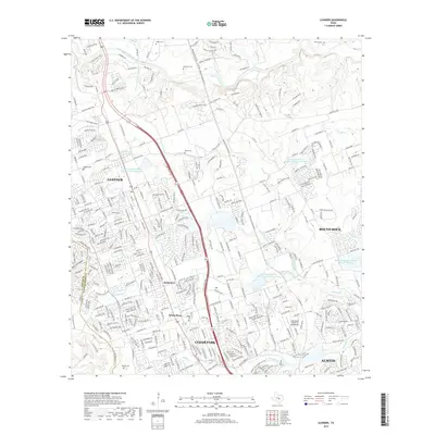
2019 Map of Leander
USGS Topo · Published 2019About this map
Leander and Cedar Park anchor this modern survey of the growing corridor north of Austin. The landscape is defined by the limestone-influenced hydrology of the Edwards Plateau, where the South Fork San Gabriel River and numerous tributaries like Block House Creek carve through the terrain. Evidence of regional water management is prominent, with several structures including Soil Conservation Service Site 2 Reservoir and Soil Conservation Service Site 4 Reservoir distributed across the drainage basins. For those tracing the area's rural roots, several small burial grounds remain preserved amidst the suburban expansion, including Bagdad Cem, Upchurch Cem, and Davis Cem. Smaller historic place names like Walkerton and White Stone persist alongside specialized landmarks such as the Hank Sasser Airport at Breakaway and the sprawling parklands near Walsh Lake.
Find a feature on this map
352 named features on this map. Tap any name to fly to it.
Don’t see what you’re looking for? This feature index may not catch every label — zoom into the map to look around manually.
Map Details
Editions of this 2019 Leander Map
This is the sole edition of this map. No revisions or reprints were ever made.
Other maps of this area

1893 · Georgetown
USGS Topo · 1:125,000

1896 · Austin
USGS Topo · 1:125,000

1897 · Austin
USGS Topo · 1:125,000

1910 · Austin
USGS Topo · 1:125,000

1925 · Georgetown 4-b
USGS Topo · 1:48,000

1928 · Round Rock
USGS Topo · 1:62,500

1930 · Austin-2
USGS Topo · 1:48,000

1932 · Mt. Bonnell
USGS Topo · 1:62,500

1949 · Round Rock
USGS Topo · 1:62,500

1951 · Round Rock
USGS Topo · 1:62,500