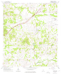
1963 Map of Learned
USGS Topo · Published 1976About this map
The Illinois Central railroad cuts through this Hinds County landscape, connecting the small settlement of Learned to the surrounding agricultural countryside in the early 1960s. The area is defined by a dense network of country churches and family-named landmarks, such as Reeves Chapel, Oak Grove Ch, and New Salem Ch. Significant land use is evident at the Oakley Training School and the Brown Loam Branch Experiment Station, while the Natchez Trace Parkway provides a modern transit corridor alongside older local routes.
Find a feature on this map
45 named features on this map. Tap any name to fly to it.
Don’t see what you’re looking for? This feature index may not catch every label — zoom into the map to look around manually.
Map Details
Editions of this 1963 Learned Map
3 editions found
Other maps of this area

1903 · Jackson
USGS Topo · 1:125,000

1934 · Raymond
USGS Topo · 1:48,000

1937 · Raymond
USGS Topo · 1:62,500

1937 · Terry
USGS Topo · 1:48,000

1938 · Edwards
USGS Topo · 1:62,500

1942 · Raymond
USGS Topo · 1:62,500

1943 · Terry
USGS Topo · 1:62,500

1955 · Jackson
USGS Topo · 1:250,000

1961 · Jackson
USGS Topo · 1:250,000

1962 · Jackson
USGS Topo · 1:250,000