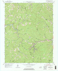
1954 Map of Leatherwood
USGS Topo · Published 1976About this map
Leatherwood and Yeaddiss anchor this mid-century portrait of the Kentucky coalfields, where the narrow valleys of Leslie, Perry, and Harlan Counties converge. The industrial heartbeat of the area is traced by the Louisville and Nashville railroad, which follows the winding course of Leatherwood Creek and Clover Fork. The map reveals a remarkably dense network of rural schoolhouses, suggesting a period of high community activity in these remote mountain hollows. From Livingston Sch to Beech Fork Sch, these labels indicate the location of civic life before the era of widespread school consolidation.
Find a feature on this map
72 named features on this map. Tap any name to fly to it.
Don’t see what you’re looking for? This feature index may not catch every label — zoom into the map to look around manually.
Map Details
Editions of this 1954 Leatherwood Map
2 editions found
Other maps of this area

1887 · Jonesville
USGS Topo · 1:125,000

1891 · Hazard
USGS Topo · 1:125,000

1891 · Jonesville
USGS Topo · 1:125,000

1903 · Harlan
USGS Topo · 1:48,000

1916 · Cornettsville
USGS Topo · 1:62,500

1916 · Harlan
USGS Topo · 1:48,000

1916 · Nolansburg
USGS Topo · 1:48,000

1916 · Hyden
USGS Topo · 1:48,000

1919 · Nolansburg
USGS Topo · 1:62,500

1919 · Hyden
USGS Topo · 1:62,500