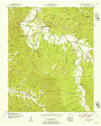
1951 Map of Leatherwood
USGS Topo · Published 1954About this map
The Buffalo River snakes through the borderlands of Perry and Wayne counties, defining a landscape of deep hollows and sharp ridges in the early 1950s. The small settlements of Flat Woods and Leatherwood serve as local hubs for a rural population connected by numerous fords and bridges, including Big Rock Ford, Slink Shoals Ford, and Mt Olive Bridge. This survey by the Tennessee Valley Authority reveals a tightly knit community structure supported by many family-named landmarks and institutions. Genealogists will find a wealth of records in the scattered country burying grounds, such as Worley Cem, Throgmorton Cem, and Merideth Cem. Educational and spiritual life is anchored by locations like the Old Union Sch, Phillips Sch, and Pope Chapel. The map documents the intricate network of watercourses, from Beech Creek to Green River, that shaped the topography and development of this Middle Tennessee region.
Find a feature on this map
86 named features on this map. Tap any name to fly to it.
Don’t see what you’re looking for? This feature index may not catch every label — zoom into the map to look around manually.
Map Details
Editions of this 1951 Leatherwood Map
3 editions found
Other maps of this area

1905 · Waynesboro
USGS Topo · 1:125,000

1936 · Graves Spring
USGS Topo · 1:24,000

1936 · Eagle Creek
USGS Topo · 1:24,000

1936 · Linden
USGS Topo · 1:24,000

1936 · Leatherwood
USGS Topo · 1:24,000

1936 · Negro Hollow
USGS Topo · 1:24,000

1936 · Clifton
USGS Topo · 1:24,000

1936 · Waynesboro
USGS Topo · 1:24,000

1936 · Topsy
USGS Topo · 1:24,000

1936 · Pope
USGS Topo · 1:24,000