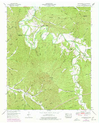
1951 Map of Leatherwood
USGS Topo · Published 1977About this map
The Buffalo River meanders through the heart of this mid-century survey, defining a landscape of deep bends and high ridges at the border of Perry and Wayne counties. The waterway is a focal point for local navigation, marked by numerous river crossings including Slink Shoals Ford, Bunch Ford, and Big Rock Ford. Small settlements like Flat Woods and Leatherwood serve as anchors for the surrounding rural hollows. High points such as Whitehead Ridge and Smith Hill look down over a network of family-named cemeteries, including Merideth Cem, Pitts Cem, and Throgmorton Cem, which are invaluable for genealogical research. The primitive Meat Road and various tracks connecting sites like the Flat Woods Lookout Tower reflect the upland timber and agricultural character of the region during this era.
Find a feature on this map
77 named features on this map. Tap any name to fly to it.
Don’t see what you’re looking for? This feature index may not catch every label — zoom into the map to look around manually.
Map Details
Editions of this 1951 Leatherwood Map
3 editions found
Other maps of this area

1905 · Waynesboro
USGS Topo · 1:125,000

1936 · Graves Spring
USGS Topo · 1:24,000

1936 · Eagle Creek
USGS Topo · 1:24,000

1936 · Linden
USGS Topo · 1:24,000

1936 · Leatherwood
USGS Topo · 1:24,000

1936 · Negro Hollow
USGS Topo · 1:24,000

1936 · Clifton
USGS Topo · 1:24,000

1936 · Waynesboro
USGS Topo · 1:24,000

1936 · Topsy
USGS Topo · 1:24,000

1936 · Pope
USGS Topo · 1:24,000