
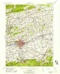
1943 Map of Lebanon
USGS Topo · Published 1943About this map
Lebanon sits at the heart of this wartime survey, showing a dense urban core flanked by the rail corridors of the Reading and Pennsylvania lines. During the early 1940s, the surrounding countryside was a busy landscape of small villages and crossroads. To the north, Jonestown and Fredericksburg anchor the Swatara Valley, while the east is dotted with Lutheran and Reformed landmarks like Kimmerlings Ch and the Heidelberg Meeting House.
Find a feature on this map
127 named features on this map. Tap any name to fly to it.
Don’t see what you’re looking for? This feature index may not catch every label — zoom into the map to look around manually.
Map Details
Editions of this 1943 Lebanon Map
2 editions found
Other maps of this area

1889 · Pottsville
USGS Topo · 1:62,500

1891 · Pottsville
USGS Topo · 1:62,500

1891 · Lebanon
USGS Topo · 1:62,500

1892 · Lykens
USGS Topo · 1:62,500

1892 · Hummelstown
USGS Topo · 1:62,500

1892 · Pine Grove
USGS Topo · 1:62,500

1893 · Lykens
USGS Topo · 1:62,500

1893 · Lebanon
USGS Topo · 1:62,500

1899 · Lebanon
USGS Topo · 1:62,500

1902 · Wernersville
USGS Topo · 1:62,500