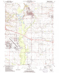
1991 Map of Lebanon
USGS Topo · Published 1991About this map
Scott Air Force Base dominates the southwestern portion of this landscape, its expansive infrastructure including Scott Lake and multiple radio towers positioned near the boundary of Shiloh Valley Township. To the north, the historic campus of McKendree College sits at the heart of Lebanon, which serves as a significant educational and residential hub along the Baltimore and Ohio Railroad. The surrounding terrain is a mosaic of agricultural fields and small settlements like Summerfield and Hagemann.
Find a feature on this map
62 named features on this map. Tap any name to fly to it.
Don’t see what you’re looking for? This feature index may not catch every label — zoom into the map to look around manually.
Map Details
Editions of this 1991 Lebanon Map
This is the sole edition of this map. No revisions or reprints were ever made.
Other maps of this area

1906 · Breese
USGS Topo · 1:62,500

1907 · Breese
USGS Topo · 1:62,500

1907 · Belleville
USGS Topo · 1:62,500

1910 · Okawville
USGS Topo · 1:62,500

1912 · New Athens
USGS Topo · 1:62,500

1935 · Lebanon
USGS Topo · 1:24,000

1937 · Collinsville
USGS Topo · 1:24,000

1937 · O'Fallon
USGS Topo · 1:24,000

1940 · Okawville
USGS Topo · 1:62,500

1949 · Lebanon
USGS Topo · 1:24,000