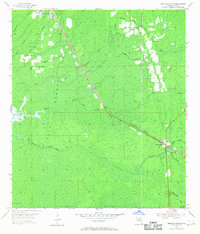
1968 Map of Lebanon Station
USGS Topo · Published 1968About this map
Gulf Hammock dominates this part of Levy County, characterized by a complex network of waterways like the Waccasassa River and Wekiva Creek. The landscape is defined by its transition from wooded hammocks to watery sloughs, with the Atlantic Coast Line railroad cutting a sharp diagonal across the terrain. At Lebanon Station, the rail line intersects with local infrastructure near the Lebanon Lookout Tower, marking a vital point of transit and observation in the mid-20th century.
Find a feature on this map
28 named features on this map. Tap any name to fly to it.
Don’t see what you’re looking for? This feature index may not catch every label — zoom into the map to look around manually.
Map Details
Editions of this 1968 Lebanon Station Map
This is the sole edition of this map. No revisions or reprints were ever made.
Other maps of this area

1954 · Yankeetown SE
USGS Topo · 1:24,000

1954 · Otter Creek
USGS Topo · 1:24,000

1954 · Bronson SW
USGS Topo · 1:24,000

1954 · Gainesville
USGS Topo · 1:250,000

1955 · Lebanon Station
USGS Topo · 1:24,000

1955 · Withlacoochee Bay
USGS Topo · 1:24,000

1955 · Waccasassa Bay
USGS Topo · 1:24,000

1955 · Yankeetown
USGS Topo · 1:24,000

1955 · Tidewater
USGS Topo · 1:24,000

1955 · Bronson SE
USGS Topo · 1:24,000