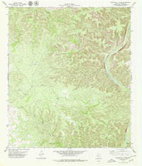
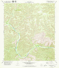
1979 Map of Lechuguilla Creek
USGS Topo · Published 1979About this map
The Devils River dominates the eastern edge of this landscape in Val Verde County, cutting a deep path through the limestone topography. This mid-1970s survey captures a transition point in the West Texas terrain, where the winding waterway is joined by several significant drainages including Lechuguilla Creek and Dead Mans Creek. The interior is characterized by complex canyon systems like Rough Canyon and Dark Canyon, which define the local drainage patterns toward the river.
Find a feature on this map
13 named features on this map. Tap any name to fly to it.
Don’t see what you’re looking for? This feature index may not catch every label — zoom into the map to look around manually.
Map Details
Editions of this 1979 Lechuguilla Creek Map
This is the sole edition of this map. No revisions or reprints were ever made.
Other maps of this area

1941 · Feely
USGS Topo · 1:62,500

1944 · Dry Devil
USGS Topo · 1:62,500

1944 · Devils Lake
USGS Topo · 1:62,500

1944 · Baker Crossing
USGS Topo · 1:62,500

1958 · Del Rio
USGS Topo · 1:250,000

1964 · Del Rio
USGS Topo · 1:250,000
1972 · Satan Canyon
USGS Topo · 1:24,000
1972 · Gillis Ranch
USGS Topo · 1:24,000
1972 · Comstock
USGS Topo · 1:24,000
1979 · Telephone Canyon
USGS Topo · 1:24,000