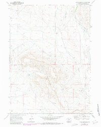
1969 Map of Leckie Reservoir
USGS Topo · Published 1980About this map
Elk Mountain dominates the central landscape of this Sublette County quadrangle, rising above a high-altitude terrain defined by essential water management and ranching operations. The Leckie Reservoir sits to the west of the mountain mass, while the Elkhorn Ditch and Little Sandy Creek provide vital irrigation and drainage across the eastern reaches of the sheet. The presence of the Arambel Ranch near the center of the survey illustrates the isolated nature of late 20th-century Wyoming livestock operations, where human settlement was sparse and anchored by dependable water sources. Long-established land divisions are noted by the intersection of Townships 28 and 29 North, cutting through the high country where several springs emerge from the slopes. The topography is marked by significant drainages like Long Draw, which carves through the undulating plains between the mountain and the creek beds.
Find a feature on this map
9 named features on this map. Tap any name to fly to it.
Don’t see what you’re looking for? This feature index may not catch every label — zoom into the map to look around manually.
Map Details
Editions of this 1969 Leckie Reservoir Map
2 editions found
Other maps of this area

1955 · Lander
USGS Topo · 1:250,000

1958 · Lander
USGS Topo · 1:250,000

1958 · Parting of the Ways
USGS Topo · 1:62,500

1958 · Parting of the Ways
USGS Topo · 1:24,000

1961 · Lander
USGS Topo · 1:250,000

1969 · Leckie Reservoir
USGS Topo · 1:24,000

1969 · Leckie SW
USGS Topo · 1:24,000

1969 · Jensen Meadows
USGS Topo · 1:24,000

1969 · Tabernacle Butte
USGS Topo · 1:24,000
1969 · Big Sandy Reservoir SE
USGS Topo · 1:24,000